Around this time two years ago, the Caribbean was battered by 2017's record-breaking hurricane season. Despite devastating damage to nearby islands such as Puerto Rico and the Virgin Islands, the Bahamas was an area that managed to avoid the full power of Hurricanes Harvey, Irma, and Maria.
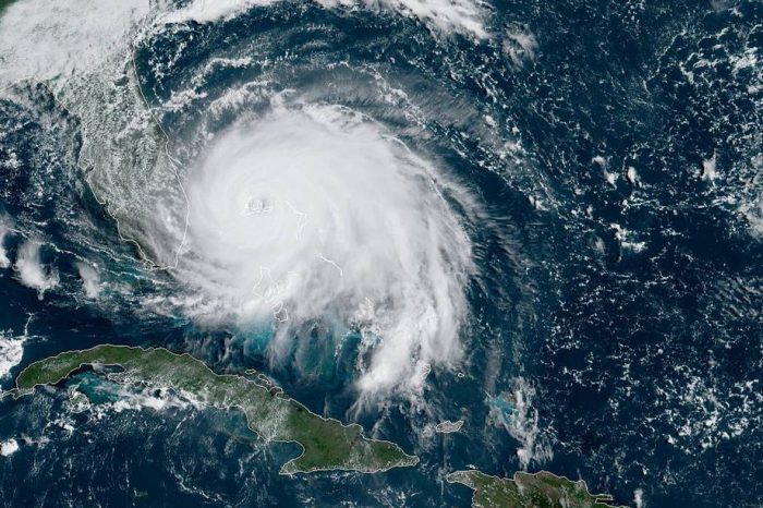
Sadly, it hasn't been so lucky in 2019. Hurricane Dorian is the first major Atlantic Ocean hurricane of this year. Over the weekend it reached a strength of Category 5 — the most powerful rating for a storm, with winds reaching 295 km/h (185 mph).
That's powerful enough to cause incredible damage including ripping homes apart and bringing tremendous floodwaters. In fact, according to some readings, Dorian is one of the strongest hurricanes at landfall (the moment it reaches the shore) ever when it hit Elbow Cay, Bahamas on September 1.
But the worst part? It's still there.
Why is this so unusual?
Residents in Florida spent the long weekend preparing for Dorian. Experts believe that the Bahamas may have absorbed most of the storm's power and that American cities won't be hit as hard. (Getty Embed)
If you want a more detailed look at how hurricanes work, click here. But for all of their devastating power, their full force tend to move past a location in a matter of hours. For one, the storms travel fairly quickly, sweeping over islands as they carve a path across the ocean.
Also, hurricanes get their power from warm, open ocean water. As soon as one hits land, it begins to lose intensity. This is why coastal areas are the only places to really feel a hurricane. The storm calms down to a more manageable thunderstorm once it gets further inland.
But in the case of Dorian, the storm is lingering over the Bahamas two days after it first arrived. Though the storm has calmed a bit, it is still a Category 3 level storm. This makes it an extremely dangerous storm with winds of around 195 km/h (120 mph).
Flooding everywhere
Exactly why Dorian is refusing to move is something that scientists will need to research. But the effect that it is having on the Bahamas is devastating.
The Bahamas are a chain of low-laying islands — this means most residents have no real hills or higher ground to escape to. When a hurricane brings 76 cm (30 inches) of rain in a day, plus floodwaters from the ocean, there are few places to go.
This is a topographic map of Grand Bahama island.
Green: 0-15 ft
Yellow: 15-30 ft
Red: 30+ ftDorian's storm surge is estimated at 18-23 ft, which would submerge everything in green and significant parts of the yellow. Hopefully most people managed to move to safe locations. pic.twitter.com/lyoFA8mPnV
— Robert Rohde (@RARohde) September 2, 2019
Places like the airport on Grand Bahama island are under two metres (over six feet) of water — that's over the height of a full grown human. Elsewhere, people are reporting water outside their homes up to the second floor windows. But even areas with much lower water are in trouble.
Long recovery ahead
Dorian still is expected to stay over the Bahamas for most of today. And what will happen when it passes?
Many structures have been blown over or damaged by the hurricane's winds. But the floodwaters are the largest problem. Water causes major damage to homes. It also cuts off power, and affects drinking water (especially when so much of the water flooding the shores is salty ocean water that is undrinkable).
Much like Puerto Rico two years ago, the country most devastated by the 2017 hurricanes, the Bahamas have a long recovery ahead that will take months, or even years. You can see some visuals of the flooding and winds in this Washington Post video below.
 Hurricane Dorian on September 2, over the Bahamas. (NOAA/NESDIS/STAR)


