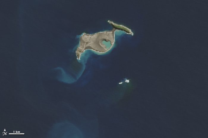
 Hunga Tonga-Hunga Ha'apai before the recent eruption. (NASA)
The South Pacific nation of Tonga is not one landmass, but many. In fact, there are 169 islands in the Kingdom of Tonga. Thirty-six of them are inhabited, with the biggest being Tongatapu—home to its capital, Nuku'alofa.
But as of this month, the most well-known island of Tonga is a small, uninhabited one: Hunga Tonga-Hunga Ha'apai. The reason why is quite explosive. Literally.
At its centre, rising from the sea floor, is a submarine (underwater) volcano. On January 15, 2022, it erupted with such force that it was the most powerful eruption in over 30 years. It sent a tsunami (tidal wave) to Peru. It was heard in the Yukon Territory. Its shockwaves were felt in space.
It also deeply affected the rest of Tonga—sending ash across much of the country, flooding many of the islands, and severing (cutting) the cable that brought internet service. Though there was much damage to structures and buildings, thankfully, very few people have died and the rebuilding process has already begun.
But back on Hunga Tonga-Hunga Ha'apai, the island looks forever changed by the blast. Where there was once a batwing-shaped island, there are now only two horns at the edges. The middle has been completely blown away. But here is maybe the most interesting thing about this earth-shattering event.
It is not so much a destruction of what always was, but a return to what things once were.
Two, then one...
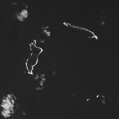
Hunga Tonga (left bottom) and Hunga Ha'apai (right top) in 1978. (Wikimedia Commons)
As you maybe already guessed, Hunga Tonga-Hunga Ha'apai used to be two islands, not one. Hunga Tonga and Hunga Ha'apai. The satellite picture above is what the two islands looked like in 1978.
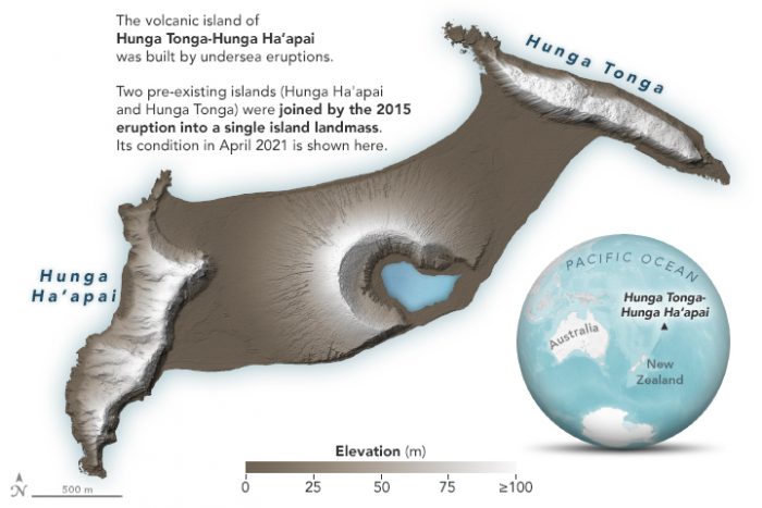
Then, in 2015, an eruption of the submarine volcano between them deposited so much new volcanic rock, that the islands were joined together. It was the first time that something like this had happened in the modern, satellite era. This meant that scientists could get an incredible look at a process that has been happening for eons. Watching a volcano build a new landmass. Here is an illustration of the islands after the 2015 eruption.
(NASA)
Incredible, right? Just think about how much lava and ash had to be pushed up from the seafloor—yes, starting under the water!—to create that much new land. And what's more, most of the island was formed in a matter of a couple days. Suddenly, Hunga Tonga and Hunga Ha'apai were Hunga Tonga-Hunga Ha'apai.
One whole island.
...and then two again
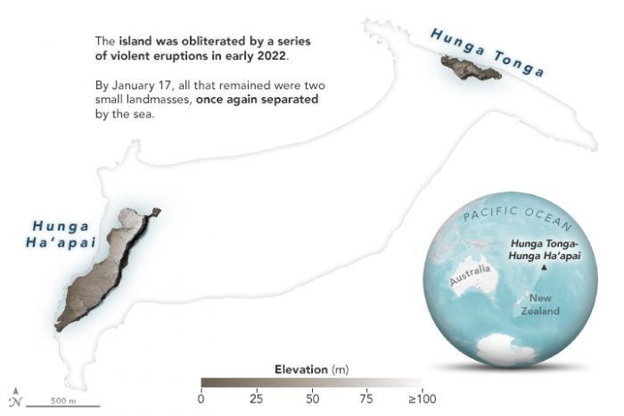
But eruptions can destroy just as quickly as they build. Which is exactly what happened after January's eruption. All of that land was blown away in an explosion that NASA says was the equivalent of "between 4 and 18 megatons of TNT." It was so powerful that it even blew away parts of the original two islands.
(NASA)
Hunga Tonga and Hunga Ha'apai are separate again.
The process began in December 2021, as scientists noticed small eruptions and tremors coming from the island. But the main blast on January 15 was truly remarkable. The kind of blast that only happens a few times a century.
#NASAWorldview Image of the Week: Explosive Eruption of #HungaTonga - Hunga Ha'apai Volcano as observed on Jan. 15, 2022 by the ABI instrument aboard the @NOAA GOES-West satellite. Learn more: https://t.co/1qBhuelg3J GeoColor Imagery provided by NOAA/NESDIS/STAR pic.twitter.com/yRkR0bfg9U
— NASAEarthdata (@NASAEarthData) January 18, 2022
Though this animation is sped up by a lot, there's no mistaking the amount of power at work. No wonder the island was blown apart into two again!
We don't see everything
All this talk of new islands being formed and then blown apart is pretty incredible, right? But, if we may, let us leave you with a final thought about the volcano at Hunga Tonga-Hunga Ha'apai. Because, they were never really just two islands in the first place.
They were always two tips of the rim of a huge underwater volcano that were poking above the ocean. Though they seemed separate, they were really just the only parts that we could see of a connected landmass. Let's go back to that 1978 image of the two islands, but this time, let's draw some red lines along the curves of those islands.
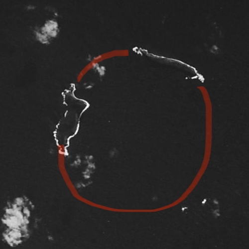
The volcano was there all along! (Wikimedia Commons)
See how they create a circle? Sort of like the circle at the top of a volcano. Maybe this view of the volcano after the 2015 eruption makes a little more sense, right?
Hunga Tonga-Hunga Ha'apai after the 2015 eruption. In the right corner, you can see one of the original two islands. (Getty Embed)
In the end, it all goes to show that the land under the ocean is just as complex and changing as the land above it. It has mountains, valleys, plains, and, yes, volcanoes that are constantly changing everything around them.
Earth is one amazing planet!