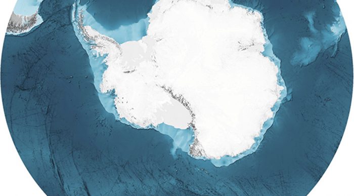
 A detail from the new map of the Southern Ocean. (British Antarctica Survey/IBSCO, 2022)
How many oceans are there? Can you name them?
For many people, the answer is four: Arctic, Atlantic, Indian, and Pacific.
And many globes and maps still agree.
But since 2000, the International Hydrographic Organization—and much of the global science community—has officially declared that there is a fifth ocean. The Southern Ocean, which surrounds Antarctica.
And now, the depths of this ocean have been mapped like never before!
A brand new sonar map has drawn out the endless plateaus, peaks, and trenches of the ocean with an impressive accuracy. It is all a part of the Nippon Foundation General Bathymetric Chart of the Oceans (GEBCO) Seabed 2030 project. This initiative is aiming to fully map out all of the ocean seabeds by 2030.
What is the Southern Ocean?
The ocean was mapped out by the RMS Sir David Attenborough, which also carries the hilariously named robot submersible Boaty McBoatface. (Getty Embed)
In the past, The Southern was seen as being part of the southern sections of the Atlantic, Indian, and Pacific Oceans. But because of its unique currents and ecosystems, scientists felt that it was worthy of being recognized as its own body of water. In fact, its main current—the Antarctic Circumpolar Current—is the world's largest, swirling around the entire Antarctic!
The decision made it the fourth largest ocean—it is larger than the Arctic, but still smaller than the other three. Technically, of course, all five oceans are connected to one another. But we like the idea of giving the Southern its due. Congratulations, you big, beautiful ocean!
All mapped out
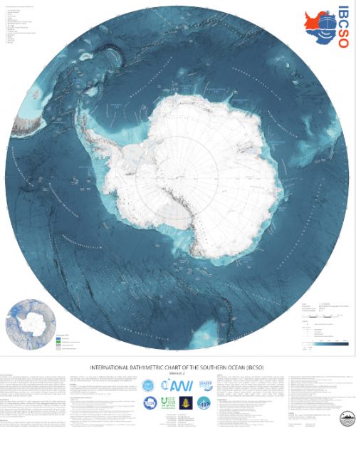
The complete new map. (British Antarctica Survey/IBSCO, 2022)
There's no better way to be recognized than by getting a portrait taken. In this case, one extremely large, detailed map.
This map took around 9 years of data gathering. It covers 48,450,304 km² (18,706,766 square miles) of sea floor, all with high resolution detailing (there is at least one depth measurement every 500 metres).
Detailed maps like this one give scientists insights into safer navigation for ships, and a better understanding of how wildlife lives in the ocean. For example, many fish love to live around underwater mountain peaks—knowing where these are can help us understand the area to conserve and keep free of human interference.
There really is so much to discover under the seas!


Wow!!
That’s so cool! 😀