 (Courtesy of AuthaGraph)
We've all seen maps of the world. They tend to look something like this:
Seems about right, no? Looking good, world! Except, a few places look a bit, well... large. Greenland is almost the same size as Canada. That can't be right. And whoah, look at the bottom... Antarctica is so wide. A quick look at a globe shows us something.
See how much smaller Greenland and northern Canada are on this globe? And do you notice how much larger Western Africa looks compared to North America here, too?
When most maps try to place the surface of the Earth (which is in 3D around a sphere) on a flat map (which is in 2D), something happens. Areas near the poles, get extremely stretched out. Meanwhile, places near the equator get a little squished. In fact, the entire flat map of the world that we're most used to seeing is inaccurate pretty much everywhere. It is distorted, or pulled and tweaked to fit the rectangular space of a map.
Fixing the world map
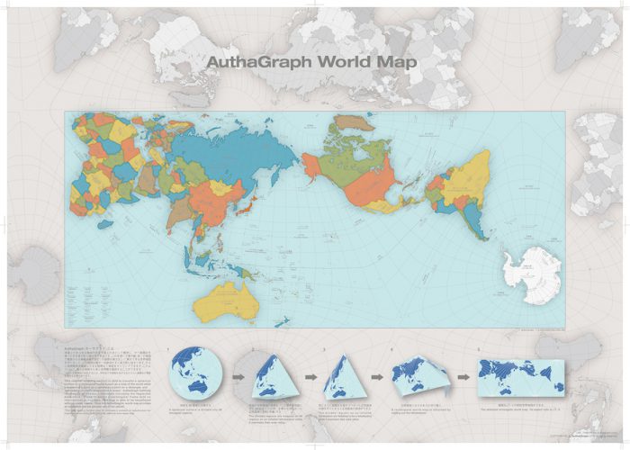
This was the problem that Japanese designer Hajime Narukawa wanted to fix. Recently he created the world's most accurate 2d map, called the Authagraph World Map. It looks like this:

The Authagraph World Map. (Courtesy of Authagraph)
Compare the two maps. What looks different? Immediately, you can see how all of the continents are tilted at new angles. Then you notice how many of the continents and countries look quite different compared to one another. Africa is much bigger now (which makes sense because it is the second-largest continent on Earth behind only Asia). Another thing? When you compare the Authagraph map to the globe, you can see how North America looks pretty much the same. Neat, right?
This past September, the judges at the 2016 Good Design Award gave it the year's top prize. In their words, “AuthaGraph faithfully represents all oceans [and] continents, including the neglected Antarctica." New textbooks in Japan are already using the map. You can even buy kits where you can fold the map from a sphere into a cone and then into a flat map.
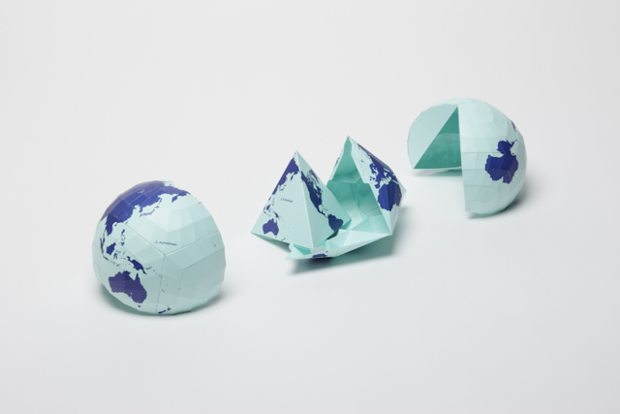
It's a sphere, it's a cone, it's Supermap! (Courtesy of Authagraph)
Talk about a fresh look at the world. Amazing!

🙂 i really loved it with this i might win my presintation thanks owl connected!!
#Awesome
#Really Helpful
#Thanks!